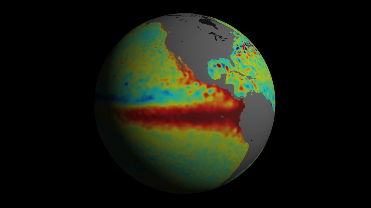
The weather phenomena that have driven up global temperatures to extreme levels during the spring is now over, according to Australian meteorologists. The water temperature in the eastern Pacific is now back to normal after a year of El Niño.
The Little Boy
The weather phenomenon El Niño, also known as the Southern Oscillation (ENSO) is a reoccurring cycle of events with fluctuations in temperature between the ocean and atmosphere in the east-central Equatorial Pacific. The turnover of water in the eastern Pacific is changed so that the surface temperature becomes too high, which affects rainfall patterns in much of the world’s tropical and subtropical regions and raises the temperature. For example, usually Southeast Asia and Northern Australia suffer drought and California often experience increased rainfall. So it has been this time.
El Niño means The Little Boy or Christ Child in Spanish. El Niño was originally recognized by fishermen off the coast of South America in the 1600s, with the appearance of unusually warm water in the Pacific Ocean. The name was chosen based on the time of year (around December) during which these warm waters events tended to occur.
This latest El Niño have first noticed a year ago, and the phenomenon culminated during the winter months. During February, March, and April the global average temperature was at a record high with an unprecedented margin.
Back to Normal
The ENSO cycle appears to have returned to neutral conditions again according to the Australian Meteorological Bureau. The surface water in the eastern Pacific is cool again.
The opposite of El Niño is called La Niña. These cycles are not as pronounced, but the average temperature is often pulled down a little with below-average sea surface temperatures across the east-central Equatorial Pacific. Ocean temperature variations for La Niña tend to be opposite those of El Niño.
La Niña means The Little Girl in Spanish. La Niña is also sometimes called El Viejo, anti-El Niño, or simply “a cold event.”
The likelihood that La Niña will form during June-August is estimated by the Australian meteorologists to be 50 percent. According to National Oceanic and Atmospheric Administration (NOAA), there is a 75 percent probability that a La Niña occurs during the fall.
This would mean that parts of Asia, Africa, and Latin America should expect more than normal rainfall and that the average temperature on Earth in the coming months will fall back to less dramatic levels.
It is unclear how fast this change will occur and how much cooler it will get. The outcome will perhaps provide an indication of how much of the recent record temperatures can be traced to underlying global warming and how much was an El Niño effect.
_____________
El Niño ends as tropical Pacific Ocean returns to neutral
__________________________