Close Menu
Illustrated Curiosity | Economics, History, Science, Space, Technology, Health, Physics, Earth
    Facebook X (Twitter) Instagram YouTube
    Illustrated Curiosity | Economics, History, Science, Space, Technology, Health, Physics, Earth
    • Earth
    • Economics
    • Environment
      • Environmental Tech
      • Pollution
      • Wildlife
    • Health
      • Health Tech
      • Medicine
      • Nutrition
      • Exercise
    • History
      • Prehistory
      • Ancient History
      • Postclassical Era
      • Modern History
    • Humans
      • Human Brain
      • Psychology
    • Life
      • Animals & Plants
      • Genetics
      • Paleontology
      • Evolution
      • Genetic Engineering
    • Physics
    • Space
      • Astrobiology
      • Astronomy
      • Extrasolar Planets
      • Space Tech
      • Spaceflight
    • Technology
      • Artificial Intelligence
      • Energy
      • Engineering
      • Materials
      • Robotics
      • Vehicles
    Illustrated Curiosity | Economics, History, Science, Space, Technology, Health, Physics, Earth
    Home » A Huge Crack Provides More Evidence That Africa Is Slowly Splitting into Two
    Earth

    A Huge Crack Provides More Evidence That Africa Is Slowly Splitting into Two

    April 9, 20183 Mins Read
    Illustration: Illustrated Curiosity
    Share
    Facebook Twitter LinkedIn Pinterest Email

    A long crack that recently emerged in the Kenyan countryside has given scientists yet more evidence that the African continent is slowly breaking apart.

    Suddenly, the ground opened in a zigzag. Eliud Njoroge Mbuga noticed how the crack emerged along the cement floor in his home. He managed to pick up some personal belongings and head out before the house collapsed.

    The crack spread to several kilometers in length, about 15 meters deep, and up to 20 meters wide in some places.

    The triggering factor was heavy rain, but scientists now firmly believe that Africa is splitting into two parts.

    The process is going to be extremely slow, so there is little reason for locals to worry about it.

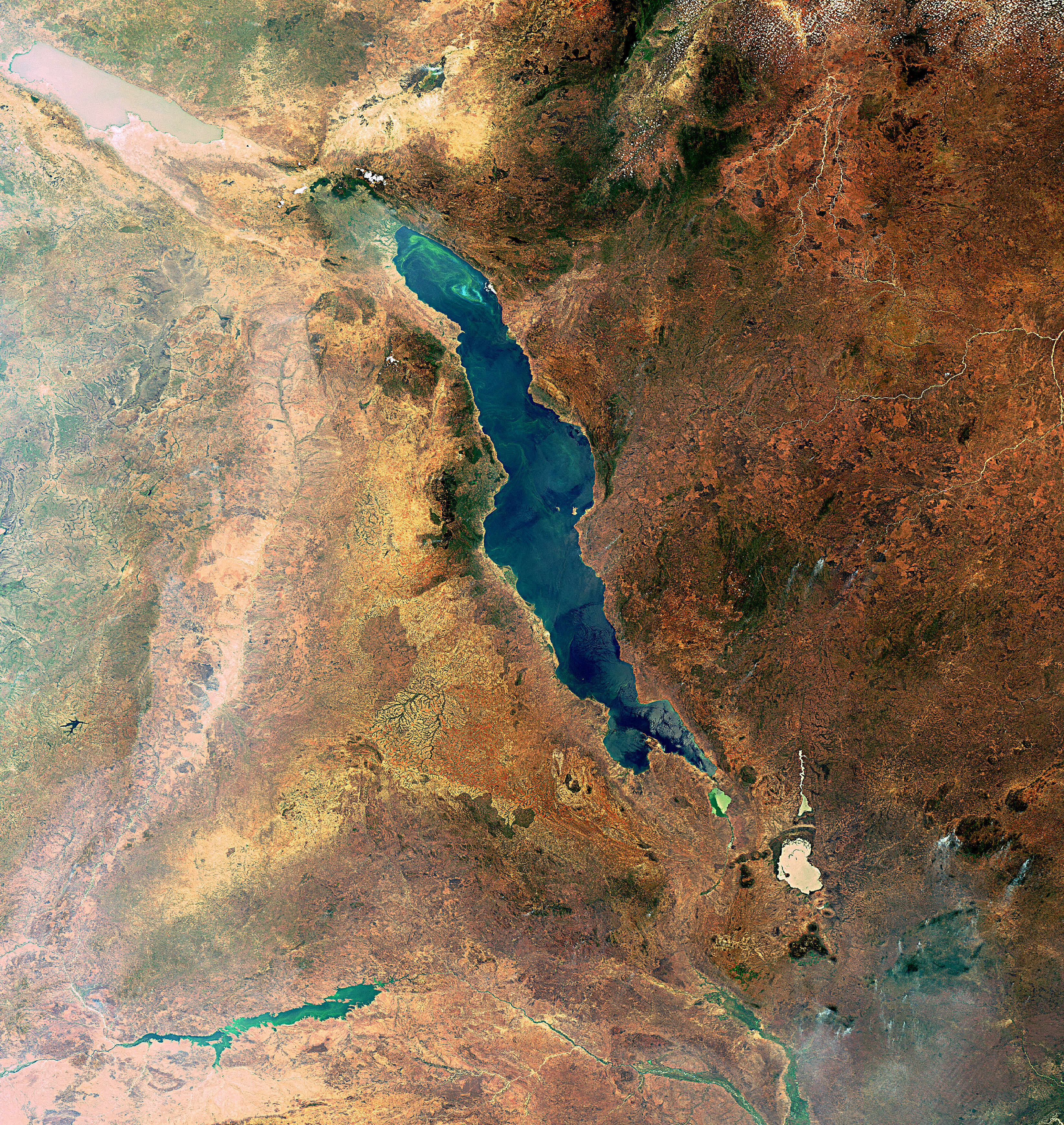
    Cracks occur from the so-called Rift Valley, a fault that extends from northern Ethiopia south to Zimbabwe. But with several other cracks occurring along northeastern Africa.

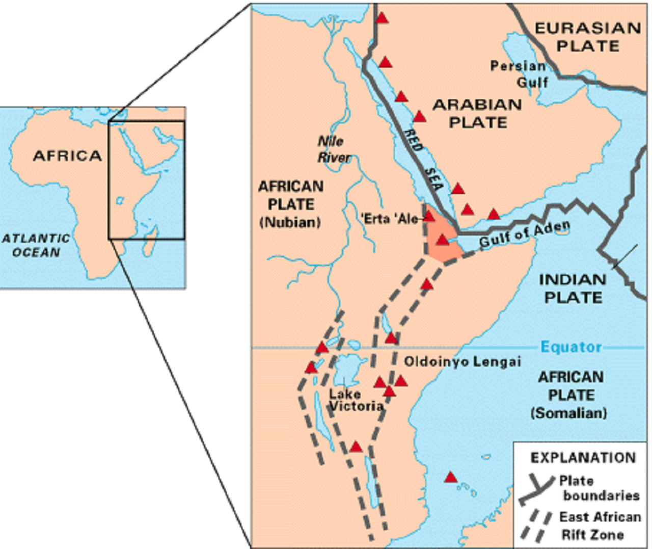
    The geological activity along the eastern edge of the Rift Valley became apparent when the Earth suddenly opened in the Kenyan countryside, according to Lucia Perez Diaz, a researcher in dismissal dynamics at Royal Holloway University in Great Britain.

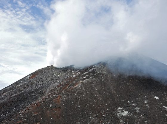
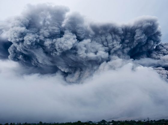
    Besides earthquakes, the African continent’s splitting into two parts will also take on other characteristics. Along the Rift Valley, there are several volcanoes, some of which several belong to Africa’s highest peaks.

    The East African Rift Zone includes a number of active as well as dormant volcanoes, among them: Mount Kilimanjaro, Mount Kenya, Mount Longonot, Menengai Crater, Mount Karisimbi, Mount Nyiragongo, Mount Meru, and Mount Elgon, as well as the Crater Highlands in Tanzania. Active volcanoes include Erta Ale, DallaFilla, and Ol Doinyo Lengai, the former of which is a continuously active basaltic shield volcano in the Afar Region of northeastern Ethiopia.

    The earthquakes resulting from the split are usually modest since the tectonic plates that are being formed are moving apart from each other, the most powerful earthquakes occur where the plates “collide” with each other.

    But the East African Rift is the largest seismically active rift system on Earth today. The majority of earthquakes occur near the Afar Depression, with the largest earthquakes typically occurring along or near major border faults.[11] Seismic events in the past century are estimated to have reached a maximum moment magnitude of 7.0. The seismicity trends parallel to the rift system, with a shallow focal depth of 12–15 km (7.5–9.3 mi) beneath the rift axis.

    The Rift Valley started to form 30 million years ago near the Red Sea, and the eastern plate appears to work itself southward at a rate of 2.5 to 5 centimeters per year.


    In a couple of millions of years, the sea will flow north along the rejection zone, and parts of what is Ethiopia, Somalia, Kenya, Tanzania, and Mozambique will eventually end up on a new plate and leave the rest of Africa behind.

    Share. Facebook Twitter Pinterest LinkedIn Tumblr Email Copy Link

    Related Posts

    The Looming Giant: Grindavik’s Potential Volcanic Eruption and its Global Implications

    November 13, 2023

    Small Warning Signs Can Reveal Volcano Eruption – before the Disaster

    October 3, 2019

    Earth’s Core Is Actually Solid According to New Research

    October 22, 2018

    Tree Ring Dating Confirms Historical Accounts of ‘Blood Aurora’ as Extreme Cosmic Radiation

    October 18, 2018

    Scientists Offer Clues to What Caused the Mass Extinction 250 Million Years Ago

    October 12, 2018

    Geoengineering, to Combat Global Warming, May Harm Crop Production

    August 15, 2018
    Recent Posts
    • The Strait of Hormuz Dilemma: Power, Energy, and an Irreversible Turning Point
    • Eggs, Cholesterol, and Heart Disease: What the Science Actually Says in 2026
    • Oil Shocks, Policy Mistakes, and the Risk of a Second Inflation Wave (Part II)
    • Oil Shocks, Policy Mistakes, and the Risk of a Second Inflation Wave (Part I)
    • Microsoft Stored a Movie on Glass — And It Could Last Centuries
    • AI, Automatic Stabilizers & Inflation
    • Largest Battles in History: Cannae — Rome’s Darkest Day
    • The Day the Alliance Died
    • Evaluating Heart Disease: How Cumulative Diet Choices Compound Your Risk
    • What Would Happen If China Attacked Taiwan?
    © 2025 Illustrated Curiosity

    Type above and press Enter to search. Press Esc to cancel.